GIS
(Geographic Information Systems)
OpreX Control of Work can be configured to use plot plans/maps hosted by WMS (Web Map Service) servers. Most major GIS providers support WMS. WMS maps can have multiple layers which can be turned on/off by the end user, and different information can be displayed at different zoom levels.
Map features can have information embedded in them (such as equipment details) so that when the mouse is moved over them a tool tip or other information can be displayed.
Current Plot Plans start out as CAD files or Satellite Images and then the images generated from them are used in system.
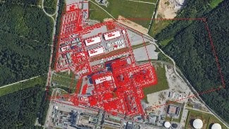
System | Features
With GIS data in the system, spatial queries can be carried out e.g.
- How many permits within 5 metres of the work area
- Automatically place permits at the correct functional location
Integration with OpreX CoW Mobile
- If you are using mobile devices, RA-P4 will be able to show you where and when people were when they entered signatures against a permit
All data entered into RA-P4’s GIS system can be tagged with owner / interested party details.
RA-P4 converts vector data into GIS friendly formats for graphical representation.
Benefits
- Allows a detailed view of large, extended areas
- Detail can increase as you zoom in
- The system supports any WMS compliant server, including ESRI ArcGIS, GeoServer & MapServer
- WMS compliant GIS Server built into the system allows easy viewing of data in your existing GIS software

Turnaround
The speed at which permits can be issued during turnarounds can have a large effect upon overall performance, with any delays in issuing impacting upon the time taken to get the job done. RA-P4’s upfront planning capability, its flexible rules and barcode controls greatly enhance this process giving potential for large savings.
Field Assistant
Mobile execution for safer, more efficient field operations Field Assistant is the mobile enablement layer within OpreX™ Control of Work, extending digital Control of Work processes directly to the point of work.
E-Learning
The Competence Classroom eLearning portal offers training to workers in an organisation for all modules, Permit to Work, Isolations, and Administration. The portal will enable basic users to receive training in basic tasks.
Risk Assessment
Robust Risk Assessment identifying all hazards present in the workplace that have the potential to cause harm enabling the necessary control measures to mitigate the risk.